
When it comes to public safety threats, in relation to our infrastructure, our roadways top the list of concerns. U.S. Roadways not only serve as a critical link for moving people from place to place, but they’re also one of the main routes for moving consumable goods, food, fuel, and critical supplies throughout the country.
Our nation’s roadways are made up of more than 4 million miles of public roads, and are critical for transporting supplies throughout the country. In fact, it’s estimated that 70 percent of all freight transported in this country, is done so by nearly 11 million trucks driving our public roads and highways. These roadways provide direct access to our nation’s ports, airports and city centers; driving our economy, and enabling goods to get to the marketplace.
With so much importance placed on our nation’s roads and highways, it’s never been so important for us to focus on maintaining this critical infrastructure. Unfortunately, our public projects have long been run by corrupt politicians, unions, and corporations who have siphoned trillions of our tax dollars into projects that have done little to address our aging infrastructure.
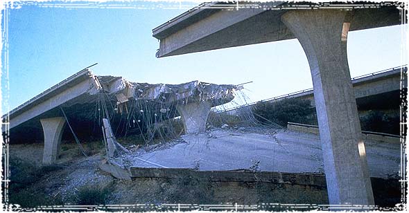
Failing Roadways & Congested Highways
According to the American Society of Civil Engineers, America’s major urban highways remain extremely congested, costing the economy an estimated $101 billion in wasted fuel annually. They estimate 33% of America’s major roads are in poor, or mediocre condition, costing us an additional $67 billion a year.
Time and money is one thing, but when it comes to public safety our roadways have become death traps. Based on current statistics, it’s estimated that as many as a third of all traffic fatalities are directly related to roadway conditions.
Evacuation Preparedness Planning
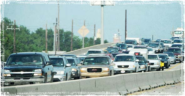
Our nation’s highways have become so congested that from a preparedness perspective, they have left us completely vulnerable to both natural and man-made disasters.
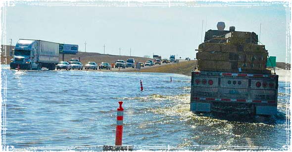
During times of mandatory evacuation, our highways are simply not setup to handle the overwhelming influx of traffic caused by an evacuation order. Time and time again we see our nation’s highways overwhelmed, so much so, that even during small-scale natural disasters it’s not uncommon to see people sitting in traffic for hours, only to have moved a couple of miles.
Since we are looking at our infrastructure threats from a Preparedness standpoint, we need to look at how it affects us during times of crisis, and what we can do to mitigate the danger.
Safely planning for Evacuations
Don’t Rely on GPS: During a disaster, where evacuation becomes necessary, the last thing you want to do is rely on your GPS. In my opinion, doing so sets yourself up for disaster, as you will likely be funneled into a choke-point with tens of thousands of evacuees who are all following the same GPS routes.
Have Multiple Routes Out: Now is the time to plan your evacuation routes, and part of any good evacuation plan is to have multiple routes out of the area. During times of crisis, the roadways are going to quickly become congested; depending on the situation, they may become impassable. Having multiple pre-planned evacuation routes will ensure your safety, and can help put you hours ahead of the mobs of unprepared evacuees.
I’ve stated many times in the past that people will become a very real threat to your safety during times of crisis, the last place you want to be during a disaster is stuck in the middle of the mob.
Look at Alternatives: Besides roadways, you should know every possible alternative route out of your area, including off-road trails, services routes, and even hiking & mountain biking trails. These can all be found using something like Google Earth, but I also suggest learning how to read Topographic maps, which can be a lifesaver during an emergency.

I was thinking of this the other day. I was on the road traveling and traffic was so bad and backed up, I said to my wife, “imagine if people where actually trying to leave due to a disaster?” we agreed that the roads would be un-usable.
I was thinking this when a poster on another website had his bugout land 1300km away from where he is and had to traverse near a city. Why not bug in until the traffic dies down then leave was my suggestion to him.
as a trucker I can say the roadways are horrificly bad. I’ve seen 40 of the lower 48 and they go from passing to free milkshakes.
The three images are exactly why I moved out of the Dallas/Ft. Worth (DFW) area. Not the best move. I am now north of Seattle. I went from maybe three decent ways to get out of DFW to maybe three decent ways out of the Seattle area. And those are through mountain passes.
The one thing one should do when planning a way out of an area is to plan a way out of an area. Interstate highways are completely useless. Get a decent map of ALL roads in your state, and whichever state/s you are going through. As an example, there is a “Backroads of Texas” road map book that has well over 1,000 miles of roads one will never find on any GPS device. Most are farm roads and quite easily found. The state of Washington has a fairly decent web site with printable maps with almost every usable road on it.
I have printed all maps for WA and have several routes marked. I have been on most of the marked routes, and indicated things like gas stations, food stores, hardware stores, etc. Depending on the time of the year I should be able to get east of the Cascade Mountains fairly easily. I would highly suggest that anyone perusing this web site and has an interest in surviving the current administration find maps for the area they are in and mark and explore the roads for at least two safe routes out of the area. That is if you live in a “metro-plex” of 100,000 or more two-legged latte drinkers.
One thing I did have a habit of doing is marking the places where water was easily available. It is very nice to have water sources known. National Park locations are another good item to mark down. Most of them have water available. Most from gravity-fed sources so you don’t have to depend on power being available.
Depending on the time of the year, one or more of your “escape routes” may or may not be passable. Make notes!! It is also a good idea on your reconnoitering of the selected routes to look for places to “park-n-hide” for an overnight stop. Note that any place at the side of the road is probably not a good place to stop. Rest stops are definitely a no-no. Every sleeze-oid in the area will be hanging around like vultures to relieve you of anything and everything you have.
And, one thing I was told from a vehicle tire place, if you are driving on non-highly traveled roads to “bug-out”, be sure to take one can per tire of fix-a-flat, or something similar. If you have a flat way the hell out in the boonies, changing a tire will probably not be the most fun you’ll have. ust make sure you can get to the jack so you can raise the tire off the ground to get enough of the fix-a-flat compound in the tire and make the tire more round than flat on one side. Same goes for the engine…….have extra water and oil!! Poor engine probably hasn’t worked this hard since you got it.
OK, this has gone way beyond the subject of roadways. I just want to make available as much usable, or selectively usable, information that I can. Hopefully someone will find some of it useful.
hawkeyes