Whenever you’re heading out on a hike, a hunt, or a trip into the wilderness – especially in remote or unfamiliar areas – carrying a map and a compass is a must. Even if the area is known to you, or you plan on staying on marked trails, you should still always carry a map and compass.
Every year thousands of hikers and outdoorsman are lost in the wilderness in areas they thought they were familiar with.
How to Use Topographic Maps & a Compass
Topographic maps are created from aerial photography and satellite imaging; they describe the shape of the land, allowing you to see three-dimensional landscapes on a two-dimensional map. The maps define natural and manmade features like hills, valleys, vegetation, waterways, trails, bridges and roads.
To be able to use these types of maps out in the wilderness, you need to learn how to read a topographic map. When reading a topographic map, you need to visualize a 3-dimensional view of what the symbols and contour lines on the map are showing.
The following image below illustrates how a topographic map conveys three-dimensional information.

Using the maps contour lines can tell you a lot about the terrain, including steepness, ruggedness, and ground cover. The most important thing to remember when reading a TOPO Map is that CLOSE contour lines indicate VERY STEEP SLOPES, while FARTHER SPACED contour lines indicate a more LEVEL terrain. For example, in the image above, the white area on the top of the hill would be relatively flat. You can tell this on the map from the lack of contour lines around this location.
Topographic Maps Show Much more than just Contours
The great thing about Topographic maps is the large amount of useful information they provide. Besides showing you things like elevation and steepness of slopes, they also include symbols that represent things like roads and trails, railroads, buildings, streams and waterways, water tanks, campgrounds and vegetation.
During an emergency situation these topographic maps can literally become your lifeline, showing you exactly where to find food, water and your way out of trouble.
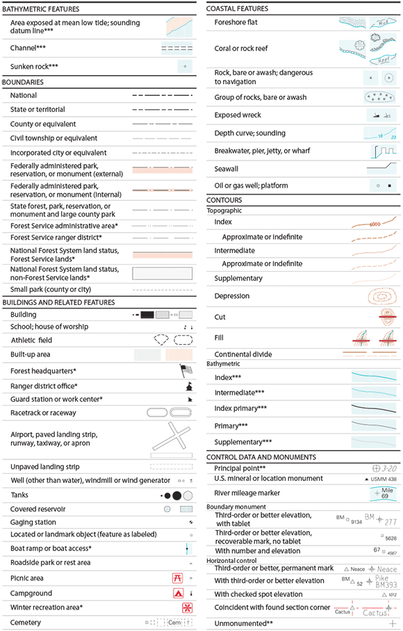
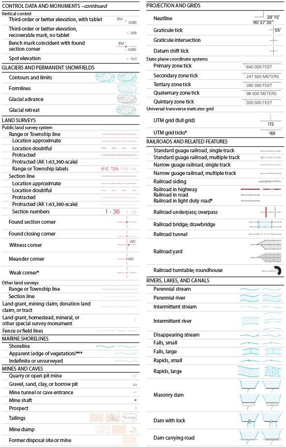
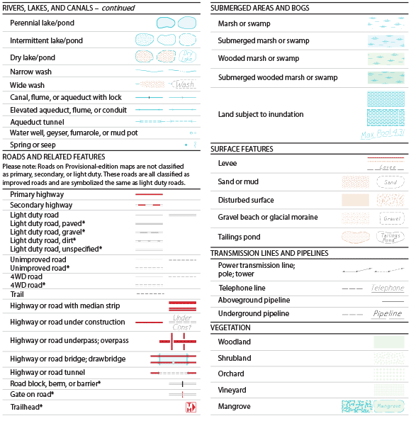
Topographic Map Symbols
The following is a list of the most current USGS Topographic Map Symbols. You can download our printable version here:


For what it is worth…
Reading a topographic map at night like those water resistant National Geographic maps using a green LED light allows all the contour lines and symbols to be enhanced and easier to read than a white or red light.
That may be correct, but defeats your night vision. The use of red lense at night is nit to give best reading ability, but to allow reading whike retaining your night vision.
Once you expose cones and rods of eyes to any light besides red, you must wsit 30 min to aquire your natural nught vision again.
The only way to retain some, if you need to use light, is to clise and cover your strong eye, so at least one eye retains your natural night vision, while other regsins after 30 min of darkness
Yes, red light is better for night vision, but the red light also impacts your depth perception. A good trade off is the green light, which offers better retention of your night vision than a white light, but does not detract from your night vision while retaining your depth perception.
Dont know about anywhere else, but in Missouri the Conservation department actually has regular classes on how to read maps and use a compass. Good stuff to know, and the classes are free. Thanks for chart, I needed a copy !
Well this is awesome, I will be printing this out and adding it to my resources for sure. I didn’t know there were so many different symbols. Something new to learn everyday! :)
I’m in the proccess of teaching a Scout/Nav course to a Militia group.
As for so many symbols; being a military Scout (19D) we are well aware of all of these.
So, it is hard to find resources without creating them. This is great!. A nice pre-made legend.
Hey Tom,
The whole Scout/Nav course sounds great.How would someone be able to get into those courses? Is it expensive?
Thanks in advance Tom and GOD Bless
I think a road leading to abrupt dead end should have a symbol of obama. LIke maybe a pile of crap with big ears or something.
I use my county’s tax records online (there’s a mapping function) to scout land. I can add contour overlays as well as overlays for water lines, political borders, roads, utility rights of way, easments, etc.
So much for privacy but it is a great tool to use.
I used to get topo maps from a local map store, but it’s gone out of business. Can you tell me where I can get printed topographic maps? Thanks!
I buy my topo maps from mytopo dot com
Good quality, customizable maps.
I just bought a few maps from the USGS sight and found that the maps that have a 2013 revision date on them no longer show the structures or the locations of the National Guard base near my town. The older revision dates still have these as well as other needed locations noted.
So if you want to get the maps with what used to be normal information on them I’d start to check for the pre-2013 revisions soon. Check the 2014 edition of ACHILLES, VA
This is a great resource for learning how to read these maps. I have always wondered though with that many map symbols, how long the average person would spend really trying to figure out what’s what on these maps?
thanks a lot for the downloadable version to print that will come in handy.