

In today’s world of Google Maps, Alexa, and GPS, not many people are equipped to find their way out of the wilderness should their technology fail. Even with a compass, most people lack the skills to get out. But let’s say you are one of the rare people left who can navigate with only a paper map and a compass; what happens when you find yourself out in the wild, surrounded by nature’s beauty, but you suddenly realize you’ve lost your compass?
For many, panic probably sets in pretty quickly. But fear not, with the right skills you can still find your way back home even without the aid of a compass.
Celestial Navigation
Navigating by the stars, also known as celestial navigation, is a navigation method traditionally used by sailors to find their way using the stars and other celestial objects. When the stars are out and the night sky is clear, celestial navigation can be your guiding light to getting back home.
By familiarizing yourself with constellations and identifying key stars, you can determine the directions. The North Star (Polaris) in the Northern Hemisphere, for instance, lies almost directly above the North Pole, making it an excellent reference point to find north.
Learning Resources:
- Celestial Navigation: A Complete Home Study Course
- Celestial Navigation: A Practical Guide to Knowing Where You Are
Using the Sun and Shadows
The sun is can serve as a compass during daylight hours using the Shadow and Stick Method. To find north in the Northern Hemisphere, position a stick vertically in the ground and mark the tip of its shadow. Wait for about 15 minutes, and mark the new position of the shadow’s tip. The line connecting the two marks points roughly east to west, with the first mark indicating west.
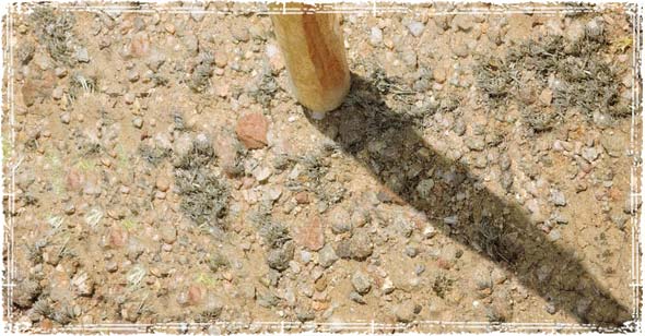
How to use the Shadow and Stick Method to Find the Direction?
- Find a stick.
- Place the stick into the ground.
- Take a stone and mark where the end of the shadow hits.
- Leave the stick sit in place for approximately 15 minutes.
- After 15 Minutes, mark the next shadow point with a rock.
- Place a line from one rock to the next rock, this should give you a rough east-west line.

Natural Landmarks and Wildlife
Observing the landscape around you can offer valuable clues about where you are at. Mountains, rivers, and other significant geographical features can help you establish a sense of direction. Additionally, keep an eye on the flight patterns of birds, and the movement of other wildlife. Wildlife can sometimes lead you in the right direction.
Improvised Compass
If you have some basic materials on hand, you can make a quick makeshift compass. One method involves rubbing a needle with a magnet and then carefully floating it on a small leaf or piece bark in water. The needle will align itself with the Earth’s magnetic field, pointing north-south.
Remember, these alternative navigation methods might not be as precise as a compass or your GPS devices, but in a shitty situation where you have nothing else on hand, they can mean the difference between being lost and finding your way back home.


Very Interesting !
if you have a watch and the sun is up, point the hour hand at the sun , 1/2 the distance ccw to 12 high is South
Is there an illustration of this somewhere?
Or North, if you’re in the Southern hemisphere…
No, it only shows North in the Southern Hemisphere if you have a counter-clockwise watch! Failing that, you need to mentally work out the left-right reflection of your normal watch ! I am in Kagaroos’ country!
if you have a watch and the sun is up, point the hour hand at the sun , 1/2 the distance ccw to 12 high is South, no need for sticks and stones
UM the first and second illustration show a change in the shadow but not on in the sun which would be physically impossible especially in that you are measuring changes in the suns position in the sky.
Its a simple picture cut it some slack. It doesn’t matter that the sun is in the wrong position.
How far do you think the sun moves in 15 minutes? I don’t believe the human eye could see the difference.
…..Plus, if you need the picture to make sense out of those clear, concise directions, finding east is going to be the least of your problems in a survival situation!
If you’re in a forest and can’t see the sun, or if cloud cover blocks the sun, find a stream, a creek, any running water. Follow the creek, stream, et al. A creek becomes a stream, which becomes a river. Rivers flow to the ocean. People live near rivers. It’s impossible to get lost in the wilderness if you can find a running body of water.
Following a creek downstream isn’t such a good idea. Yes there there is often civilization at the ocean river-mouth, but how far will that be?
Travel along a creek or river is often particularly difficult and slow due to dense vegetation, and maybe mud, boulders, etc.
On a ridge-line, you have the best visibility, and the best chance of making yourself noticed by a plane, etc.
Michael Ossipoff
Tony–
What you describe is a fully valid sun-compass.
What it amounts to is the universal equatorial ring sundial, used as a sun-compass.
The universal equatorial ring dial can be used as a sun-compass in conjunction with information abot the time–adjusting its hanging-ring for your latitude, turn it on its vertical axis till it gives the right time. That’s similar to your method.
The universal equatorial ring-dial can also be used as a sun-compass without knowing the time. It has a provision for measuring the solar declination (angle north or south of the celestial equator). Rotate the device about its vertical axis till the declination-reading is correct, and that’w when the ring’s polar-axis is pointing toward the north.
A yacht-navigation book has published an ingenious folded cardboard version of the universal equatorial ring sundial:
A card is folded at a right angle. Each half, on the two sides of the fold, is square. A string can hold the folded card at a right angle.
One square will be be held in the equatorial plane, and an edge of the other square is the gnomon that casts its shadow on the equatorial-plane square.
Both squares have, marked on them, quarter-circle protractors, which take the place of the equatorial ring.
Which square you use as the equatorial plane depends on whether the season is on the winter or summer side of the equinoxes.
There’s even provision for measuring the solar declination, just as with the usual universal equatorial ring-dial.
It can do anything that a universal equatorial ring dial can do, but it can be easily made on paper, pasted on cardboard, and folded into a right angle.
Of course one of the quadrant-scales is used to achieve the right upward tip, according to your latitude. I use mine with a short plumb-line, consisting of a penny taped to the end of a short piece of sewing-thread. But, without the plumb-line, you can orient for latitude based on where you estimate the horizon to be (even though the horizon isn’t really visible in most forests).
To repeat my main statement: Your method consists of using a watch as a universal equatorial ring-dial–a good idea, and potentially a big accuracy-improvement over the ordinary watch method.